XXXI. Buenos Aires, Argentina


Buenos Aires, Argentina — Tyler Vallance
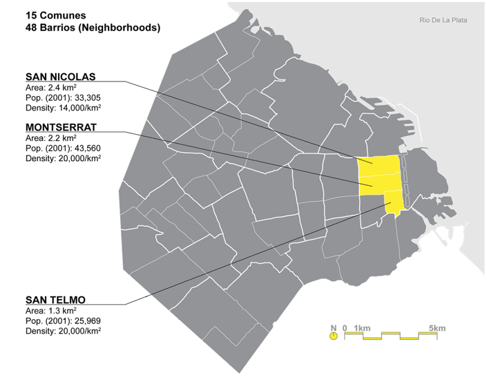
The Autonomous City Buenos Aires is the capital city of Argentina and formally apart of the surrounding Buenos Aires Province, until the city was federalized in 1880. The capital city has the largest population in Argentina. The city itself is divided into 15 comunes, or districts. Each cumune is further divided into barrios, or neighborhoods. There are a total of 48 barrios across the city.
The City Center, which was built ion the original colonial foundation is the main hub for financial institutions and corporate headquarters. Due to its history, the narrow street layout for about 20 square blocks are a grid pattern. This defined the limits until the late 19th century. Since, the expansion has been less planned and rigid. The overall character of the city takes influence from Europe & Latin America. Additionally, the city is composed of distinct, unofficial, neighborhoods, with broad avenues and individual meeting places to create a both a sense of community and also identity.
Population (2015):
Urban (Ciudad De Buenos Aires): 3,013,538 people
Metro (Buenos Aires): 17,101,037 people
Area:
Urban (Ciudad De Buenos Aires): 205.6 km2
Metro (Buenos Aires): 305,738.9 km2
Population Density:
Urban Avg. (Ciudad De Buenos Aires): 14,657 people/km2
Metro Avg. (Buenos Aires): 55.9 people/km2
Politics:
Since the adaption of the city’s Constitution in 1996, the autonomous city has been governed by the Chief of Government, who is co-elected with a deputy Chief of Government and City Legislature. Elected officials are elected to 4-year terms, with half of the City Legislature elections every two years. The city’s elected officials power is limited due the federal governments centralization tendencies. After 2007 decentralization push, each of the 15 comunes are governed by a seven-person citizen’s committee. The City of Buenos Aires also elects 3 senators to serve in the Honorable Senate of the Argentine Nation (upper house of the National Congress) & 25 national deputies to serve in the Honorable Chamber of Deputies of the Argentine Nation (lower house).
Top-Left: Obelisk of Buenos Aires: Public Plaza green & noise buffer.
Top-Right: Public Space outside National Congress Building.
Bottom-Left: Public bus hub.
Bottom-Right: Street & Density variation.
“Ciudad De Buenos, Aries,” Cityfacts, Accessed January 17, 2023, https://www.city-facts.com/ciudad-de-buenos-aires.
“Buenos, Aries,” Cityfacts, Accessed January 17, 2023, https://www.city-facts.com/buenos-aires.
“Retiro, Buenos, Aries,” Cityfacts, Accessed January 17, 2023, https://www.city-facts.com/retiro-buenos-aires.
“Balvanera,” Cityfacts, Accessed January 17, 2023, https://www.city-facts.com/balvanera.
“La Boca,” Cityfacts, Accessed January 17, 2023, https://www.city-facts.com/la-boca.
Buenos Aires, Encyclopedia Britannica,Inc., Accessed January 17, 2023, https://www.britannica.com/place/Buenos-Aires.
Wikipedia contributors, Buenos Aires. Wikipedia, Accessed January 17, 2023, https://en.wikipedia.org/wiki/Buenos_Aires.
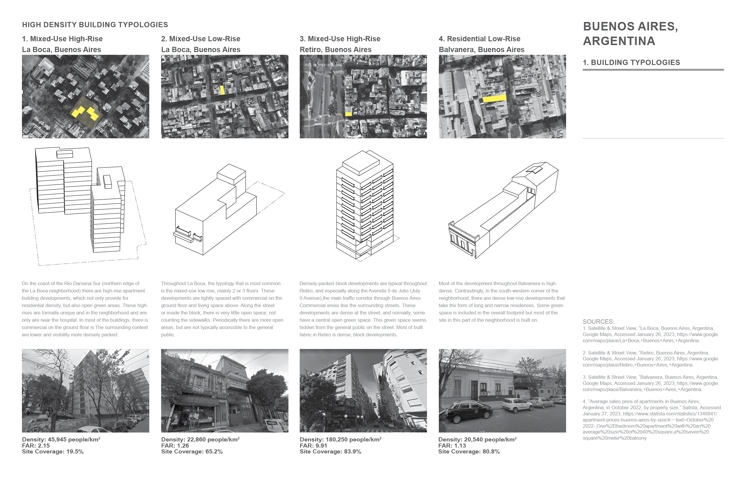
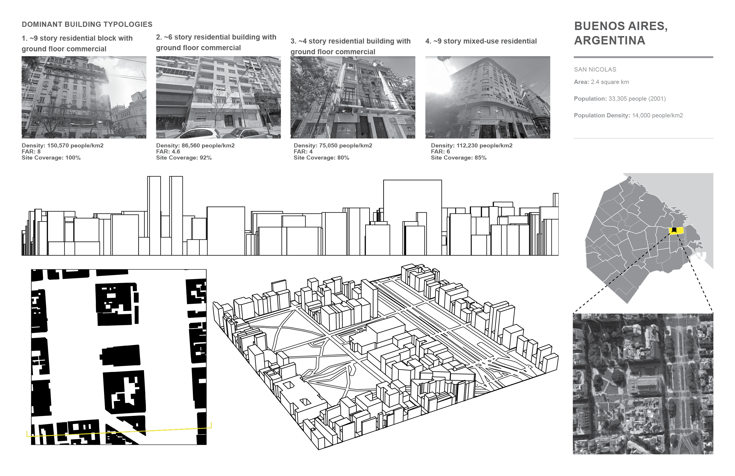
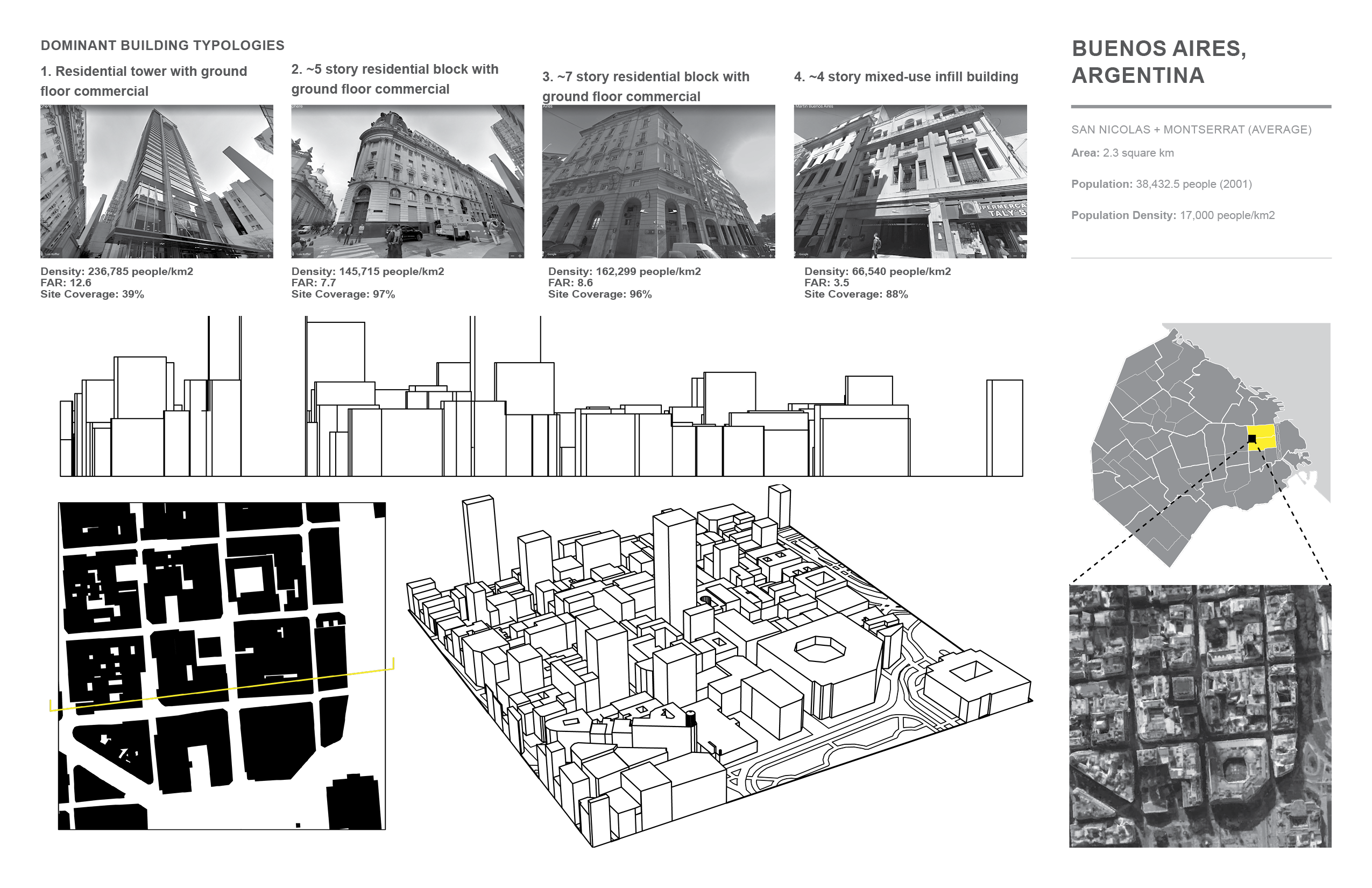
Buenos Aires, Argentina. High Density Buildig Typologies
Buenos Aires, Argentina
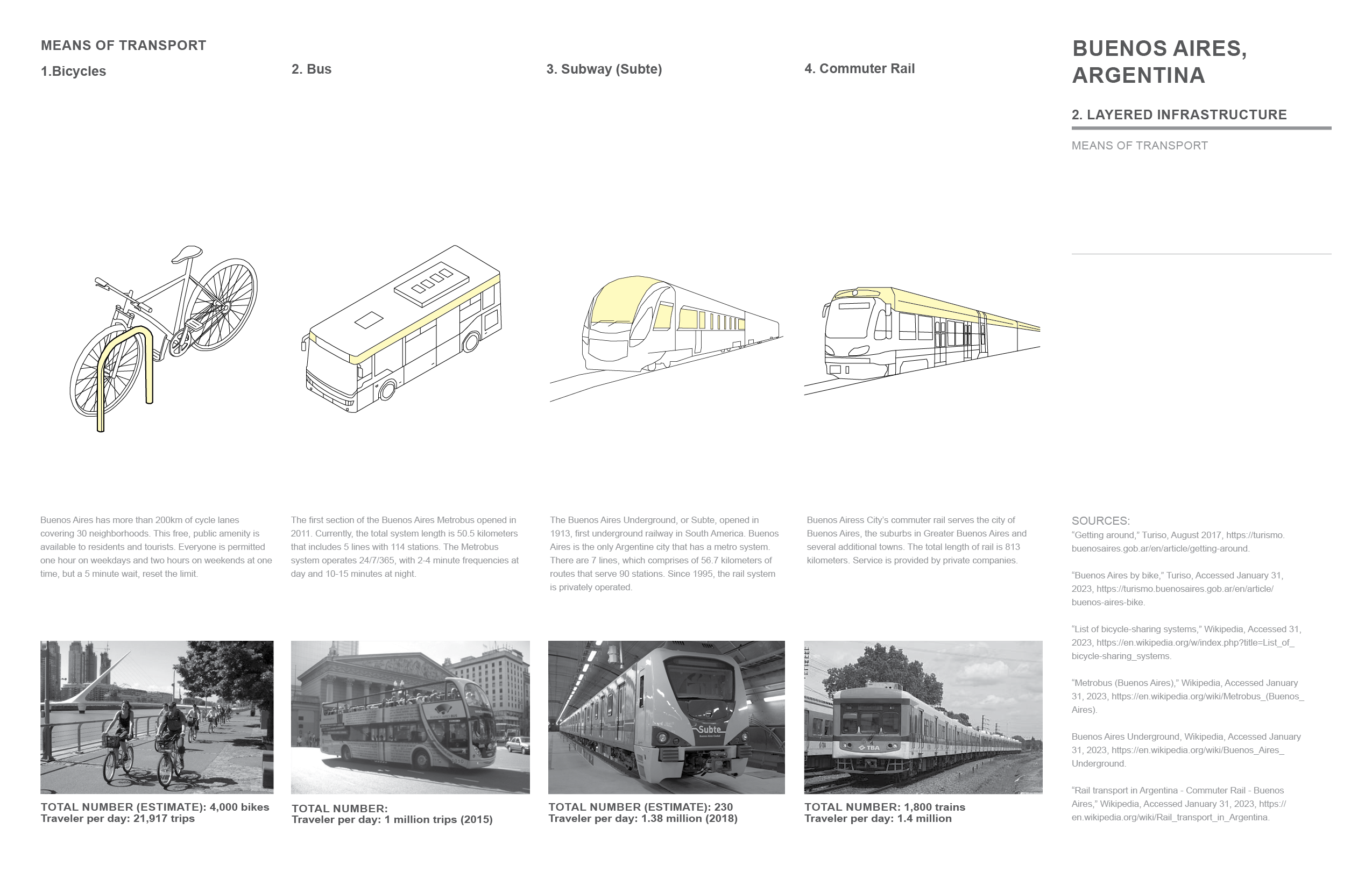
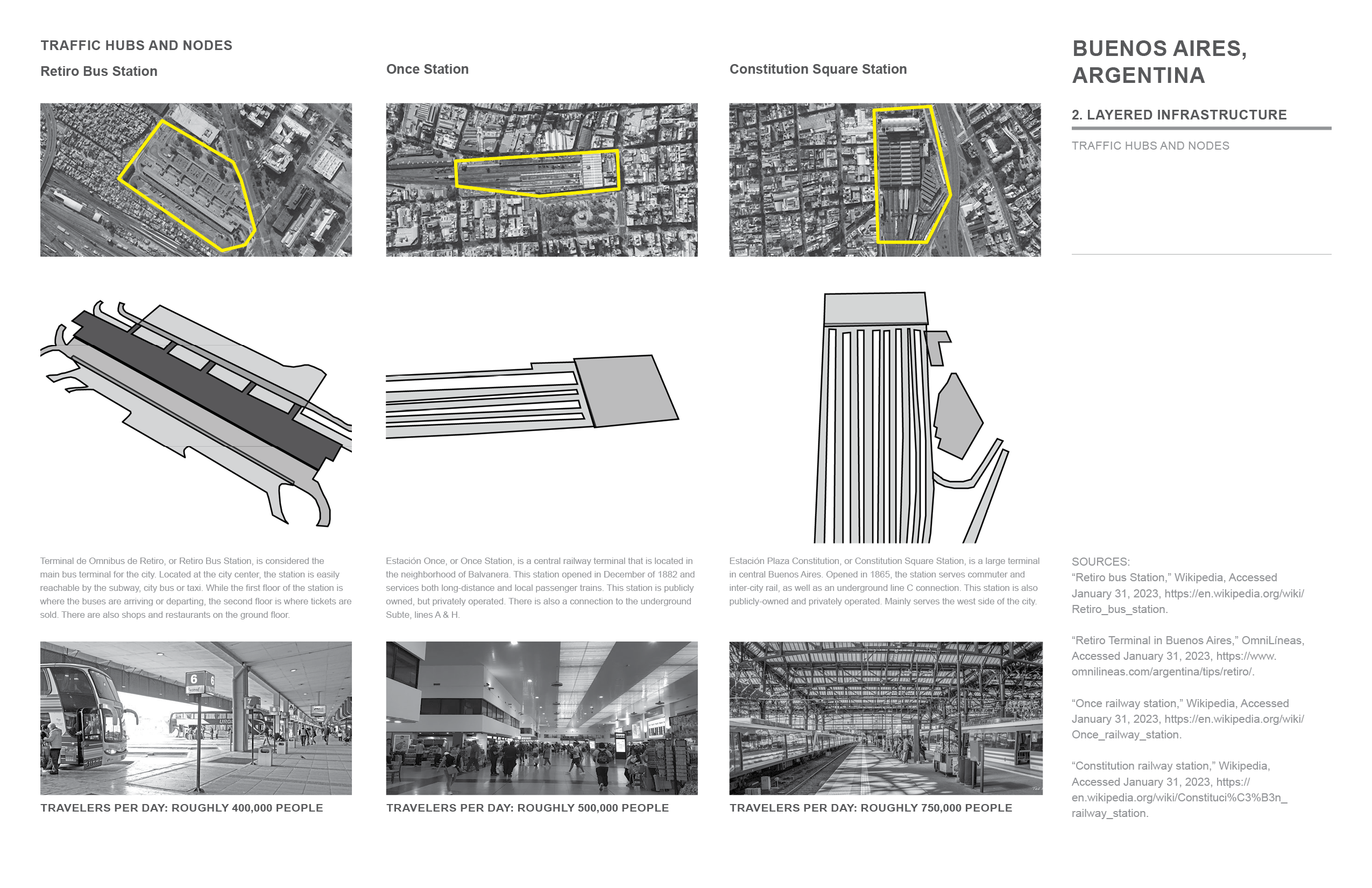
. Means of transportationBuenos Aires, Argentina . Traffic hubs and nodes
Buenos Aires, Argentina . Urban Void Spaces
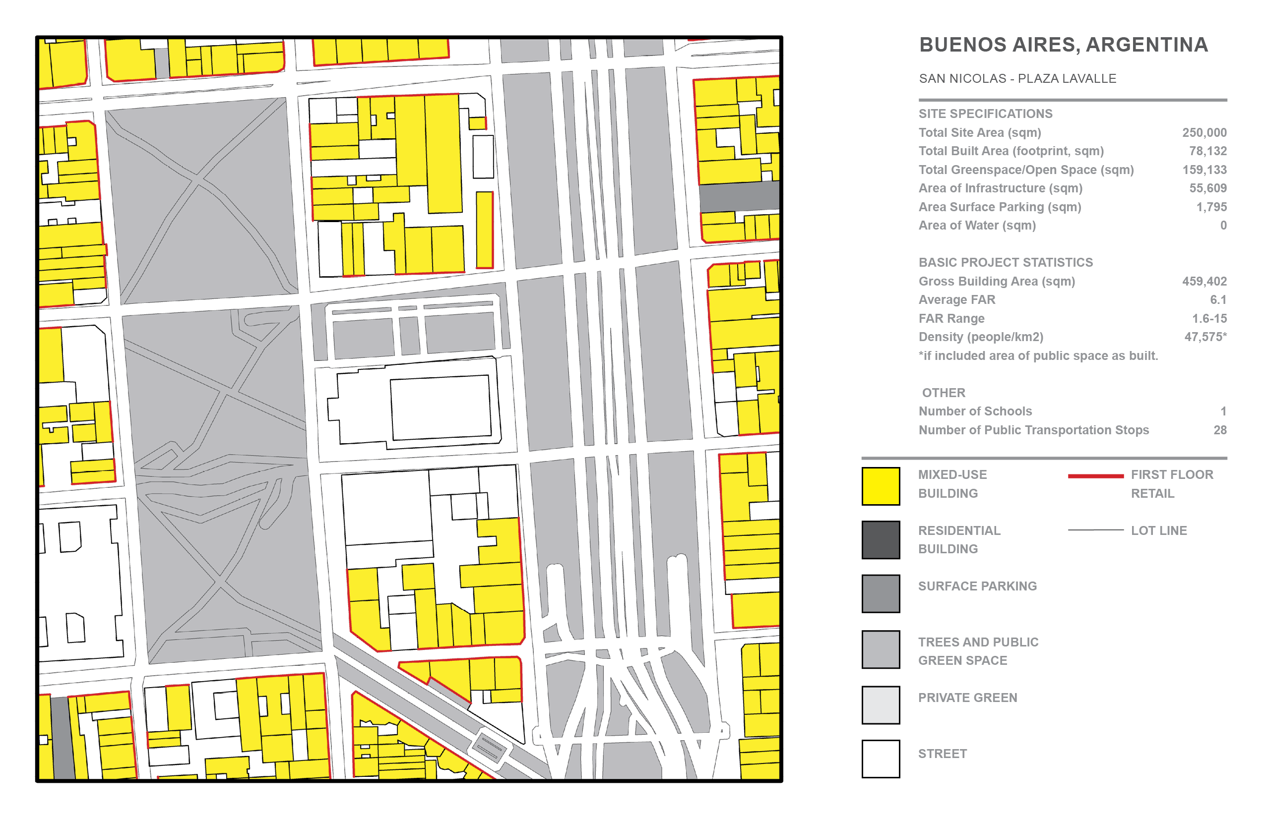
Buenos Aires, Argentina - San Nicolas:
Area: 2.4 square km
Population (2001): 33,305 people
Population Density (2001) : 14,000 people/km2
 Data Resource:
Wikipedia Contributors, “San Nicolas, Buenos Aries” Wikipedia, Accessed March 15, 2023, https://en.wikipedia.org/wiki/San_Nicolas,_Buenos_Aires.
Images/ Maps:
Satellite & Street View, “Plaza Lavalle, Buenos Aires, Argentina,” Google Earth, Accessed March 26, 2023, https://earth.google.com/web/search/Plaza+Lavalle,+Avenida+C%c3%b3rdoba,+Buenos+Aires,+Argentina.
Buenos Aires, Argentina - San Nicolas/ Montserrat:
Area: 2.2 square km
Population (2001) : 43,560 people
Population Density (2001) : 20,000 people/km2

 Data Resource:
Wikipedia Contributors, “Montserrat, Buenos Aries” Wikipedia, Accessed March 15, 2023, https://en.wikipedia.org/wiki/Monserrat,_Buenos_Aires.
Images/ Maps:
Satellite & Street View, “Piramide de Mayo, Buenos Aires, Argentina,” Google Earth, Accessed March 26, 2023, https://earth.google.com/web/search/Pir%C3%A1mide+de+Mayo,+Plaza+de+Mayo,+Buenos+Aires,+Argentina.
Buenos Aires, Argentina - San Telmo:
Area: 1.3 square km
Population (2001) : 25,969 people
Population Density (2001) : 20,000 people/km2

 Data Resource:
Wikipedia Contributors, “San Telmo, Buenos Aries” Wikipedia, Accessed March 15, 2023, https://en.wikipedia.org/wiki/San_Telmo,_Buenos_Aires.
Images/ Maps:
Satellite & Street View, “Plaza Dorrego, Buenos Aires, Argentina,” Google Earth, Accessed March 26, 2023, https://earth.google.com/web/search/Plaza+Dorrego,+Humberto+1%C2%BA,+Buenos+Aires,+Argentina.
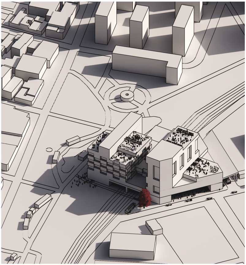
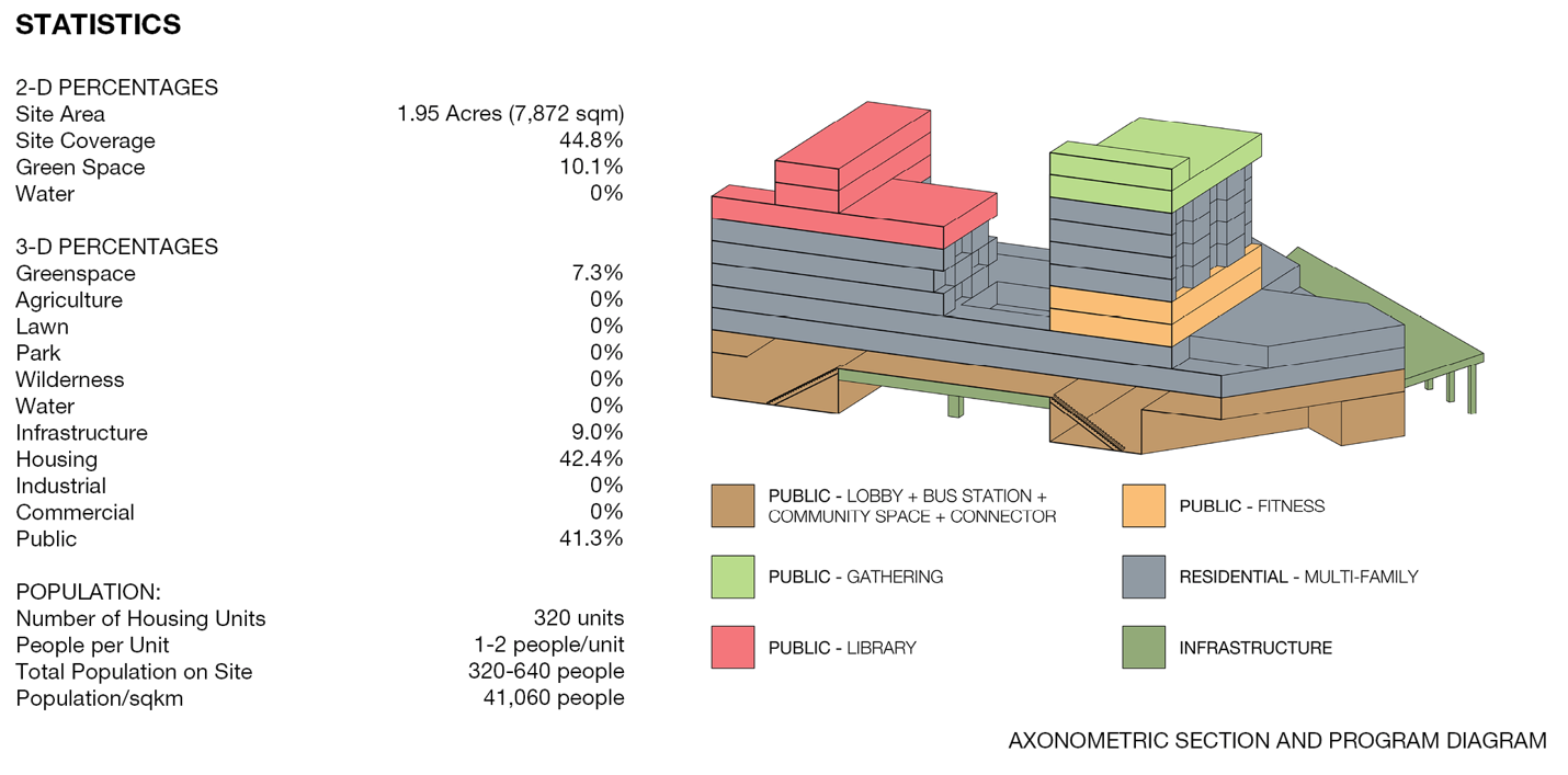
Public Connector, La Boca, Buenos Aires, Argentina
The Public Connector proposal links both the desire to connect both sides of the neighborhood of La Boca on either side of the railway and increase density. Both the Ciudad de Buenos Aires and the barrio of La Boca are projected to see a 17-18% population growth by 2040. The existing densification of the neighborhood of La Boca has been at the individual parcel level, creating great diversity in both building type and height within each city block. To reflect the need for upgraded public amenities in an area that is densifying, the City of Buenos Aires recently renovated and expanded the Benito Quinquela Martin Native Flora Park, which is located on the west side of the railway. The railway unfortunately divides the neighborhood with the public park inaccessible to the east side of La Boca.
In addition to the connection to the park, public amenities, including a bus station, are dispersed throughout. This development takes advantage of its height and provides public accessible views of the neighborhood that would otherwise not be. The existing neighborhood fabric is reflected in the varying heights within the development, creating areas of relief and public rooftops for community gathering.
La Boca, Buenos Aires, Argentina, Site Plan
La Boca, Buenos Aires, Argentina, Axonometric
La Boca, Buenos Aires, Argentina, Statistics + Program
https://www.city-facts.com/la-boca
https://www.city-facts.com/ciudad-de-buenos-aires
https://www.city-facts.com/buenos-aires
https://www.city-facts.com/ciudad-de-buenos-aires
https://www.city-facts.com/buenos-aires