XVIII. Cairo, Egypt


Cairo, Egypt
Cairo — Khalid Aburajab Altamimi
Cairo is the capital city of Egypt, and is considered a mega city, housing the largest population in the country. The Nile River runs through the Greater Cairo Area, dividing its two core governorates; Cairo and Giza governorates. The city is comprised of 74 districts distributed between both governorates. Historic Egyptian monuments are located within the Giza governorate.
Left: View of El Mohandessin Area. Right: View of Historic Cairo.
Population:
Urban: 17,697,802 people
Metro (Greater Cairo): 21,147,740 people
Area:
Metro 3,085 km2 (1191.13 sq mi)
Population Density:
Urban Average: 19,376 people/km2
Metro Average: 696 people/km2
Politics:
Being the largest city in Egypt and the capital of the country, Cairo has been at the center of significant political shifts. Being a republic, yet with significant amount of bureaucracy, much of the developments and changes that take place in the city are managed by the government. However, due to the political vacuum of 2011 caused by the uprising against Hosni Mubarak after over 30 year of rule, many informal settlements started to grow with the government leaving these developments unchecked during a transitional period. The president holds a lot of power, with the current leader being involved in many redevelopment schemes and upgrading projects. Nevertheless, due to Cairo’s situation, the president initiated the construction of a new capital city to be the seat of the government.

Top Left:
View of the pyramids in Giza. /Top Right: Overcrowded street in central Cairo.
Bottom Left: Unregulated housing in historic Cairo. /Bottom Right: Cairo city skyline from the citadel.
![]()
Cairo, Egypt. High Density Buildig Typologies
![]()
Cairo, Egypt . Means of transportation
![]()
Cairo, Egypt. Traffic hubs and nodes
![]()
Cairo, Egypt . Urban Void Spaces
Bottom Left: Unregulated housing in historic Cairo. /Bottom Right: Cairo city skyline from the citadel.

Cairo, Egypt. High Density Buildig Typologies

Cairo, Egypt . Means of transportation

Cairo, Egypt. Traffic hubs and nodes

Cairo, Egypt . Urban Void Spaces
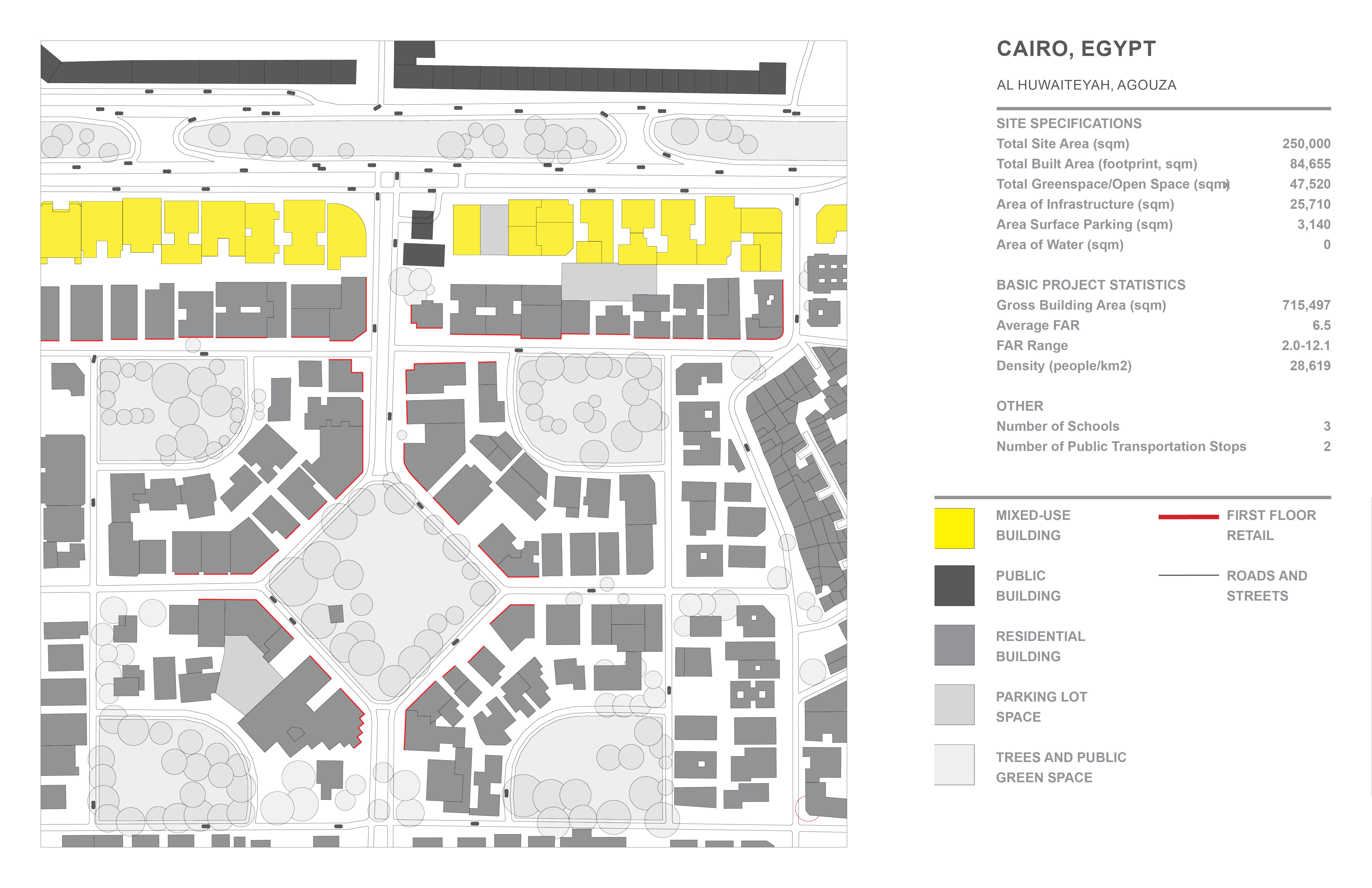
Al Huwaiteyah, El Mohandessin, Agouza:
Area: 7.349 square km
Population: 294,299 people
Population Density: 40,046 people/km2

Ard el Lewa, Al Moatamadeyah, Agouza:
Area: 7.349 square km
Population: 294,299 people
Population Density: 40,046 people/km2
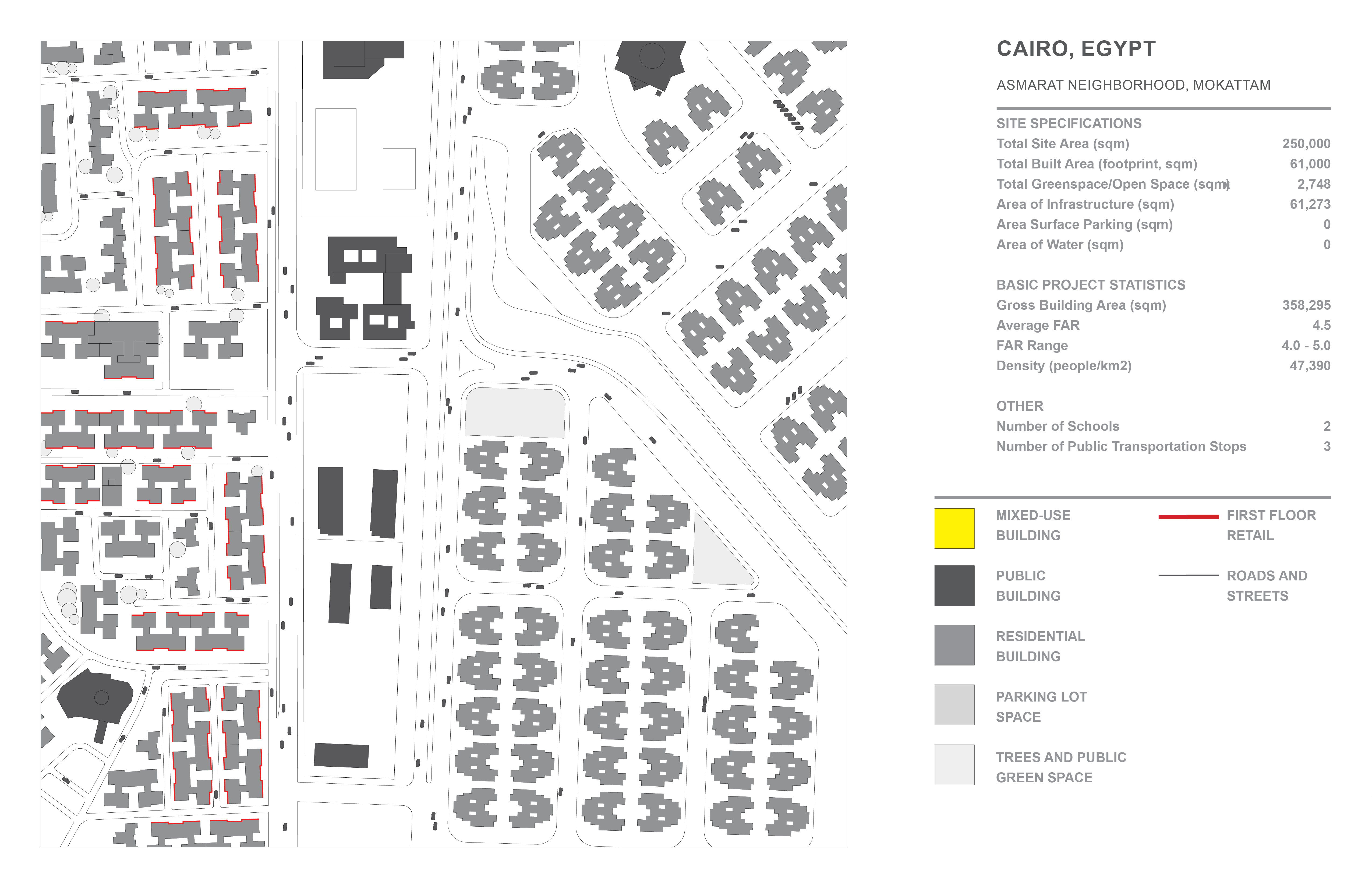

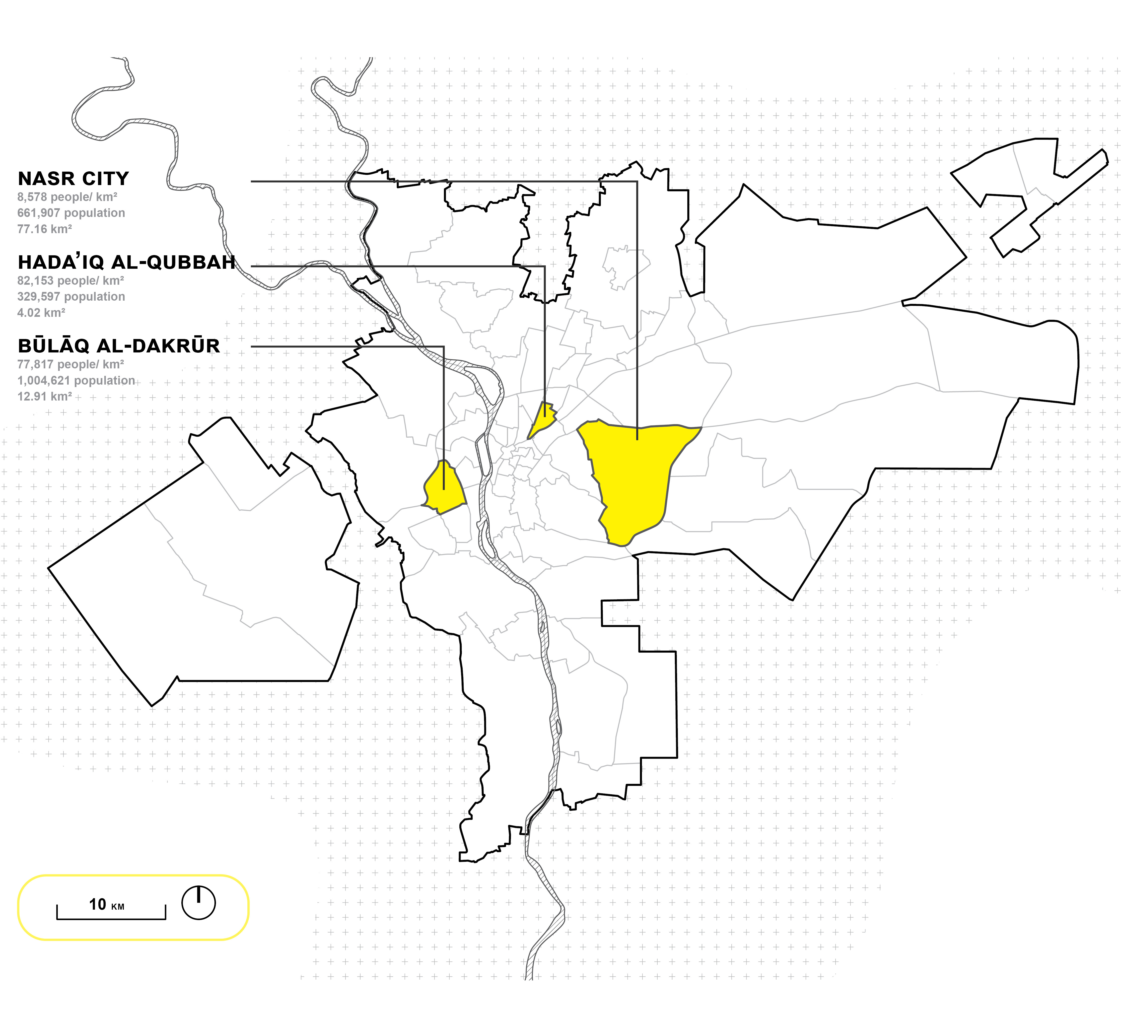
Asmarat Neighborhood, Mokattam, Nasr City:
Area: 77.16 square km
Population: 668,413 people
Population Density: 8,663 people/km2

Communal Cairo, Cairo, Egypt
Cairo has been facing significant overcrowding issues for the past several years. Rural communities moving into the city resulted in exponential population growth, with the Greater Cairo Region now being home to over 20 million people.
This shift has resulted in the emergence of many informal settlements, many of which were built of farmlands such as Ard El Lewa. Small land parcels created a tight urban fabric, with poor access to sunlight and basic amenities, lack of transit infrastructure along with no building code application which results in a potentially unsafe urban area. The government as a response initiated a housing program, but the clearing of the settlements was aimed to make way for new expensive developments. The new social housing complexes are far from central Cairo with no green infrastructure and follow modern design principles.
This proposal aims to celebrate and re-look at how to upgrade such informal settlements as an alternative, with a focus to maintain the highly communal quality of these urban areas while addressing some of the key issues facing their environment. The proposal looks into introducing a series of fillable high rises, similar to how these informal settlements function, while maintaining key agricultural spaces, introducing commercial activities and providing a network of shaded walkways between buildings.

Communal Cairo, Project Board
References:Statistics:
-
Al-Masry Al-Youm. “Egypt to Construct New Railway Station to Relieve Pressure on Ramses Station.” Egypt Independent, March 27, 2019. https://egyptindependent.com/egypt-to-construct-new-railway-station-to-relieve-pressure-on-ramses-station/.
-
Brinkhoff, Thomas. “Greater Cairo (Egypt): Districts - Population Statistics, Charts and Map.” www.citypopulation.de, May 16, 2021. https://www.citypopulation.de/en/egypt/greatercairo/.
-
Macrotrends. “Cairo, Egypt Metro Area Population 1950-2020.” www.macrotrends.net. Accessed January 20, 2022. https://www.macrotrends.net/cities/22812/cairo/population.
- Metrobits.org. “Cairo - Metrobits.org.” mic-ro.com, August 20, 2020. http://mic-ro.com/metro/metrocity.html?city=Cairo.
-
World Population Review. “Cairo Population 2020 (Demographics, Maps, Graphs).” worldpopulationreview.com, 2020. https://worldpopulationreview.com/world-cities/cairo-population.
-
Barthes, Charlotte. “Housing Cairo. From Small-Scale Informal Housing Construction to Semi-Professional Speculative Urban Schemes,” 2016. https://www.researchgate.net/publication/310677113_Housing_Cairo_From_small-scale_informal_housing_construction_to_semi-professional_speculative_urban_schemes.
-
El-Bey, Doaa. “Cairo’s Metro: A Painless Commute - Politics - Egypt.” Ahram Online, June 24, 2019. https://english.ahram.org.eg/NewsContent/1/64/336579/Egypt/Politics-/Cairo%E2%80%99s-metro-A-painless-commute.aspx.
-
Ezz, Mohammed. “How Egypt Deals with Informal Areas.” The Tahrir Institute for Middle East Policy, April 12, 2018. https://timep.org/commentary/analysis/how-egypt-deals-with-informal-areas/.
-
Hunt, Bradford. “Model Cities.” www.encyclopedia.chicagohistory.org. Accessed January 25, 2022. http://www.encyclopedia.chicagohistory.org/pages/832.html.
-
Little, Donald P, and Raymond William Baker. “Egypt - Government and Society.” In Encyclopædia Britannica, January 23, 2019. https://www.britannica.com/place/Egypt/Government-and-society.
-
Mimano, Carolyne. “Insights from Cairo: Improving Mobility through Bikeshare.” Institute for Transportation and Development Policy, October 6, 2021. https://www.itdp.org/2021/10/06/insights-from-cairo-improving-mobility-through-bikeshare/#:~:text=The%20system%20carries%20around%204.1.
-
Princeton University Library. “Cairo Buildings - Digital Maps and Geospatial Data | Princeton University.” maps.princeton.edu, 2013. https://maps.princeton.edu/catalog/princeton-1c18dh27w.
-
Tapper, Malaika. “Taming the Tuktuk? Egypt Moves to Regulate Popular Three-Wheelers.” Reuters, July 8, 2021, sec. Middle East. https://www.reuters.com/world/middle-east/taming-tuktuk-egypt-moves-regulate-popular-three-wheelers-2021-07-08/.
-
UN Habitat. “Cairo Transforms Car Park into Public Park | UN-Habitat.” unhabitat.org, May 16, 2019. https://unhabitat.org/cairo-transforms-car-park-into-public-park.
Main Images:
- Image 1
https://media-exp1.licdn.com/dms/image/C4E1BAQF5N6_sru6y_Q/company-background_10000/0/1612370029159?e=2159024400&v=beta&t=QVFvCebSc4-NaB5_6v3_Hga_yN_tscFJLOlTn9ZFu9Q -
Image 2
https://mir-s3-cdn-cf.behance.net/project_modules/2800_opt_1/8de85391621283.5e36ed46b5f3f.jpg
- Image 3
https://www.thoughtco.com/thmb/2s7iWND0wzfIoJklsaGhsQDO5cY=/2000x1325/filters:fill(auto,1)/GettyImages-200535528-001-5b5ef79146e0fb00256bffbc.jpg -
Image 4
https://www.roughguides.com/articles/cairo-through-the-ages/ -
Image 5
https://www.thenationalnews.com/world/mena/coronavirus-egyptians-grow-increasingly-resistant-to-safety-measures-1.1007496 -
Image 6
https://www.imb.org/image/crowded-cairo-streets-2/ -
Image 7
https://www.thecrowdedplanet.com/where-to-stay-cairo/