XV. Istanbul, Turkey


Istanbul, Turkey
Istanbul, Turkey — Paul Gerd
Istanbul, formerly known as Constantinople, is the principal seaport and largest urban city within Turkey. The city of Istanbul dates back to 8,000 BCE evolving along the Bosporus Strait upon a triangular peninsula separating the borders between Europe and Asia. The Bosporus Strait flows directly through the center of the city connecting the Black Sea from the north and the Sea of Marmara from the south of the city. The Bosporus Straight divides the Western and Eastern developments. Additional rivers derived from the Bosporus Straight form the Golden Horn (or Haliç Canal) further separating the western side of the city into the southern old historical (Stanbul) and northern new modern (Beyoğlu) districts. The city itself is made up of 39 municipal districts accounting for approximately one fifth of Turkey’s overall population and one third of the economic output for the country.
Istanbul, Turkey
Population:
Urban: 15,536,530 people
Metro: 15,636,000 people
Area:
Urban: 2,576.85 square km
Metro: 5,343.22 square km
Population Density:
Urban Average: 5,879 people/km2
Metro Average: 2,894 people/km2
Politics:
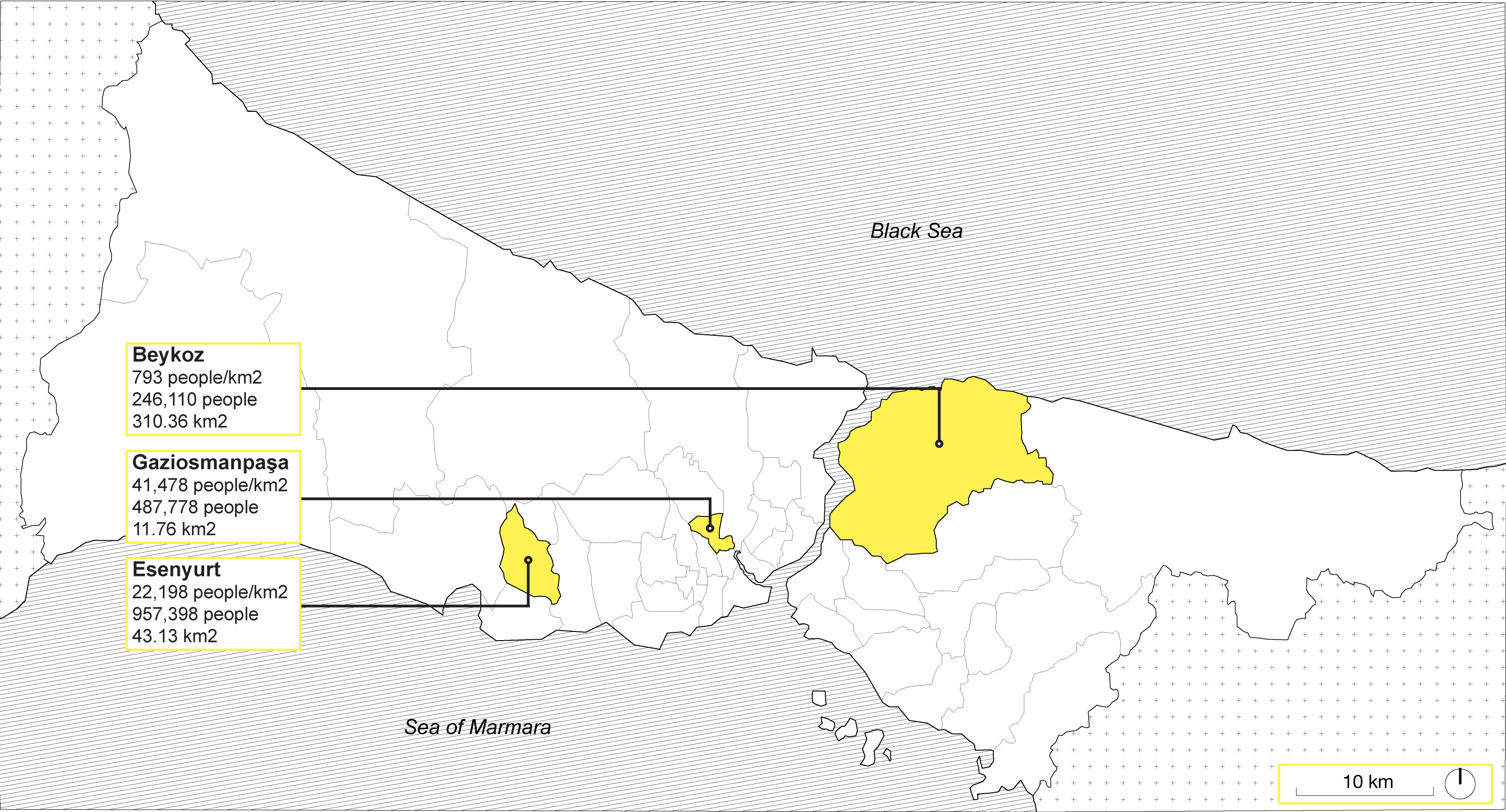
Istanbul is divided into 27 district municipalities. Istanbul utilizes a metropolitan model of governance and each district has a mayor as well as a district council member elected every five years. Urban development and decisions impacting the city are determined by the metropolitan council. District municipality members individually manage district budgets and local responsibilities including waste management, transportation, health services, as well as construction permits. There are three types of local authorities comprising of municipalities, special provincial administrations, and village administrations.

FROM LEFT TO RIGHT:
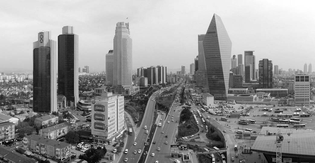
1. Skyscrapers & highways in “new” Istanbul
2. Third Hill of Istanbul with Süleymaniye Mosque
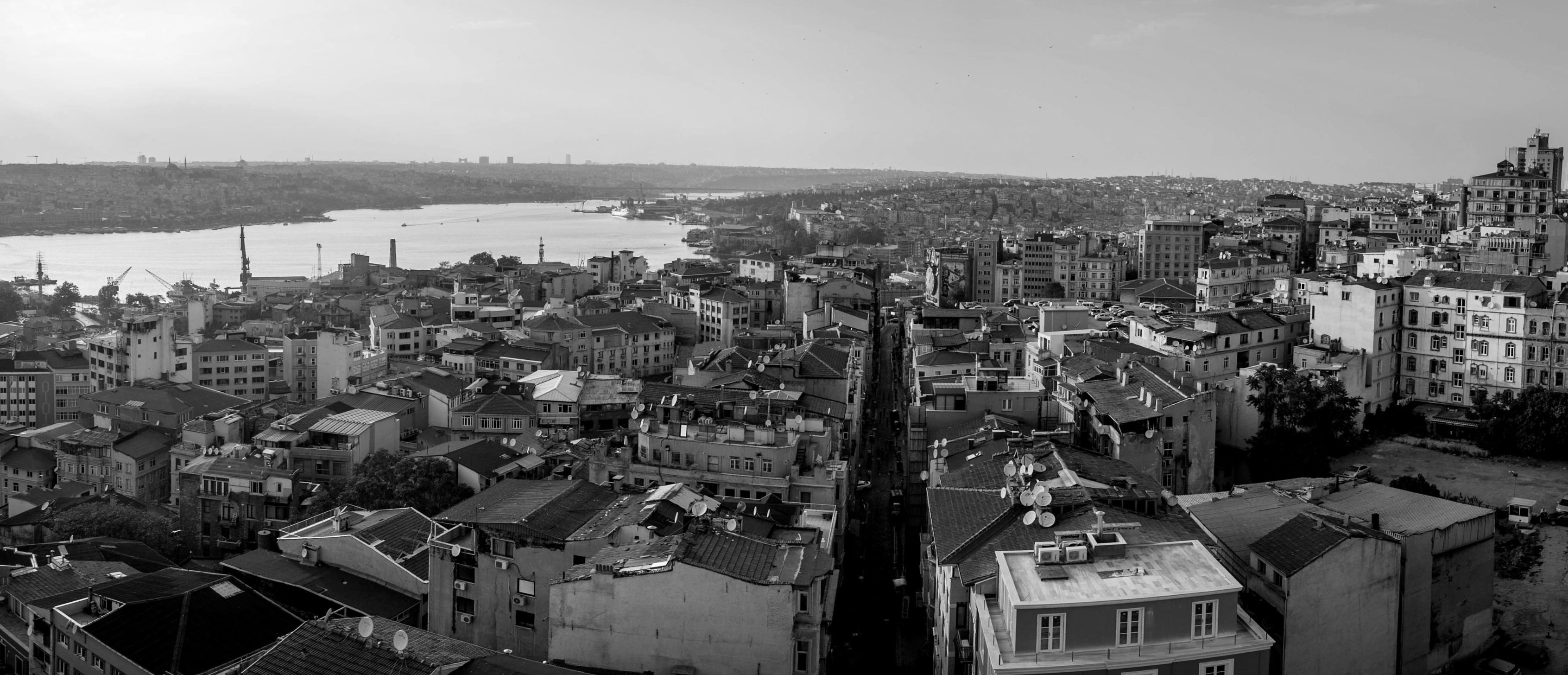
3. Urban development compared to “old” city
4. Pedestrians in Tepebaşi
1. Skyscrapers & highways in “new” Istanbul
2. Third Hill of Istanbul with Süleymaniye Mosque
3. Urban development compared to “old” city
4. Pedestrians in Tepebaşi
The Bosporus divides ‘European Istanbul’ from the districts of ‘Asian Istanbul.’ The ‘foreign quarter’ is considered to be the “new” urban district north of The Golden Horn consisting of many high-rise developments, office parks, and commercial shopping malls. To the south, “old” sectors of the city have been intruded upon with wide roads running through the sites while leaving many alleys and streets unpaved.
Portions of the “old” Istanbul districts’ walls remain intact isolating the peninsula further from the mainland.
Istanbul has withstood many natural and sociopolitical challenges recorded throughout history. Fires, earthquakes, riots, and more than sixty battles have affected Istanbul and the cities’ historical urban development. The ten-fold increasing population density in the twentieth century inflicted enormous pressures upon the cities’ infrastructures. Istanbul began to experience overcrowding, pollution, major social conflicts, and insufficiently prepared city services provided to communities. These challenges were only exacerbated by forceful seismic activity resulting in increasingly high death tolls. Additionally, with the rapid increase in the use of automobiles the city was also partially demolished to make room for large roads and highways encouraging the development of urban sprawl. Istanbul is currently facing issues of connecting socially as well as with physical infrastructures the European and Asian sides of the city separated by the Bosporus Strait.
Analyzing & Representing Urban Form
Eminönü Neighborhood, Faith District
Eminönü refers to the neighborhood and transportation hub at the base of the Galata Bridge. This transport hub is where you'll find ferries to just about everywhere, a metropolitan bus and dolmus hub, the Egyptian Spice Bazaar, the Yeni Valide Camii (New Queen Mother's Mosque), and Rustem Pasa Mosque, as well as a frenetic warren of passageways and back streets that wind their way uphill through local shops to the Grand Bazaar. The Grand Bazaar at Istanbul is often regarded as one of the first shopping malls of the world and is over 30,700 square meters.


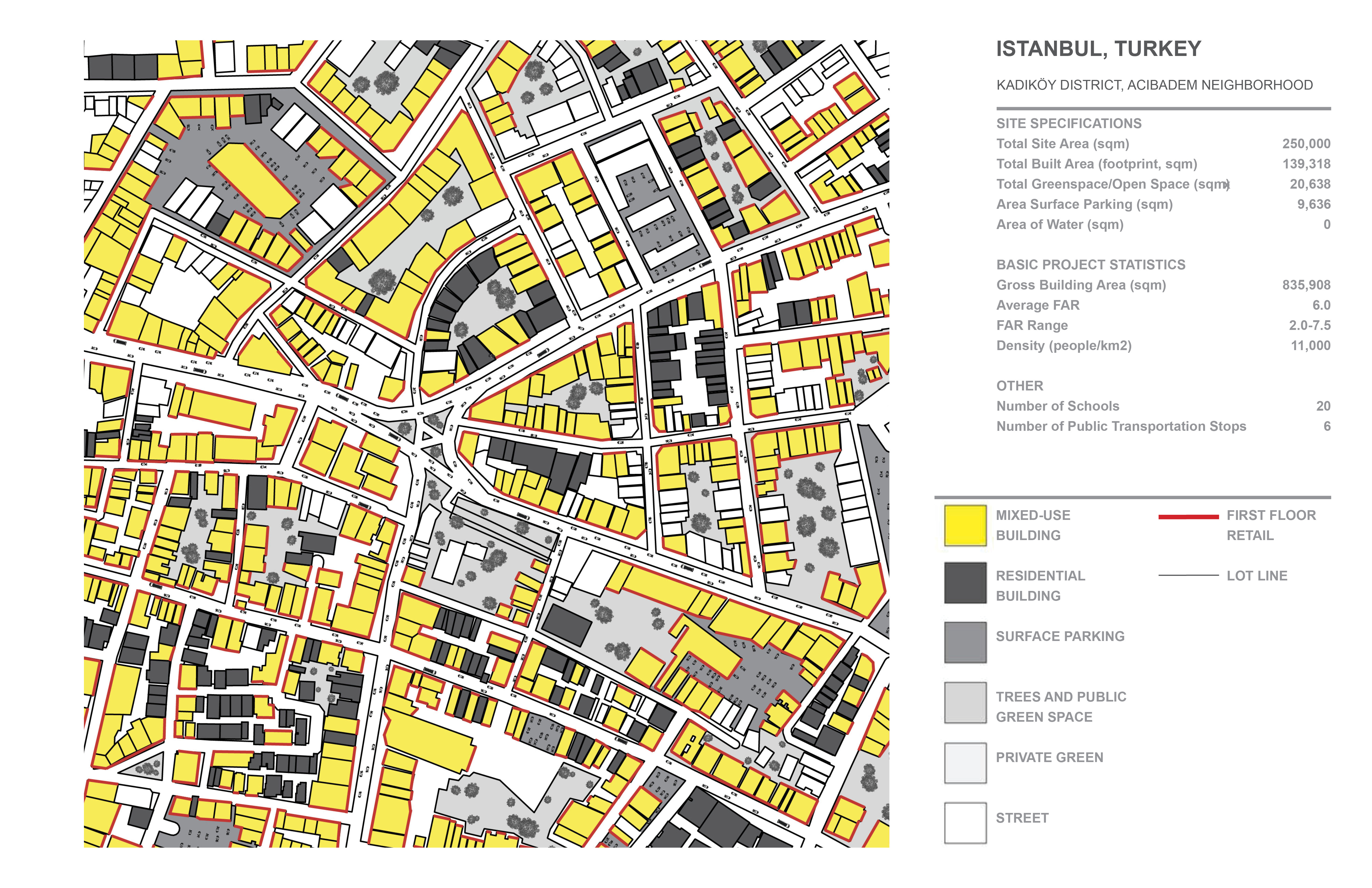
Acibadem Neighborhood, Kadiköy District
Acıbadem is a lively neighborhood of Istanbul mainly occupied by locals combining history with the future through technologies and other infrastructures. The city is full of contrasts of the ‘traditional Istanbul’ with ‘modern - day Istanbul’ as a commercial hub of Turkey. These contrasts are unique to the neighborhood and continue throughout the spaces, like a huge junction connecting every corner of the city. This area has been a settlement in Istanbul since the 1600s and includes interesting residential typologies with shared residential courtyard spaces. The neighborhood is more expensive, it is located on a peninsula with access to ferries and varieties of water transportation.

Tarlabaşi Neighborhood, Beyoğlu District
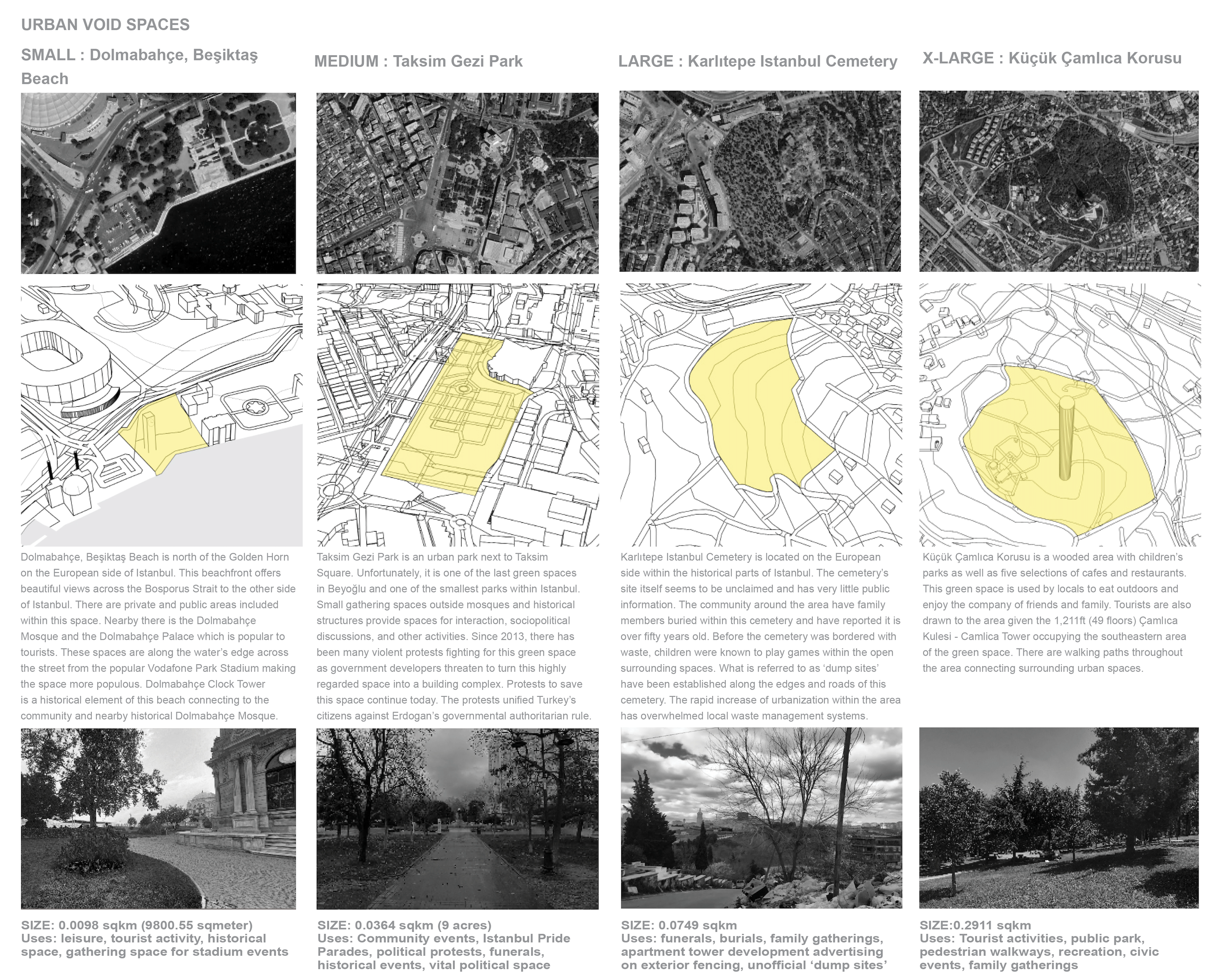
Tarlabaşi is a neighborhood North of Golden Horn currently threatened by gentrification through high rise developments. The neighborhood’s nearby publicly accessed green space is Taksim Gezi Park and is the only public outdoor space for some people in this neighborhood. Many protests have occurred in Taksim Gezi Park due to the threats of losing this green space, only to be replaced with more gentrifying high rise developments. There is a diverse group of ethnicities living here with various religious practices utilizing mosques and other historical sites nearby Taksim Gezi Park. The neighborhood also houses different social groups that are often marginalized in the city: transsexuals, sexworkers, or 'illegal immigrants on their way to Europe.' Highlighting the infrastructural beauty and the topography of the area, there are a set of stairs infamously known as the "Rainbow Stairs." Many artistic murals or scenes exemplifying the connections, creativity, and community of the neighborhood and those who live here.


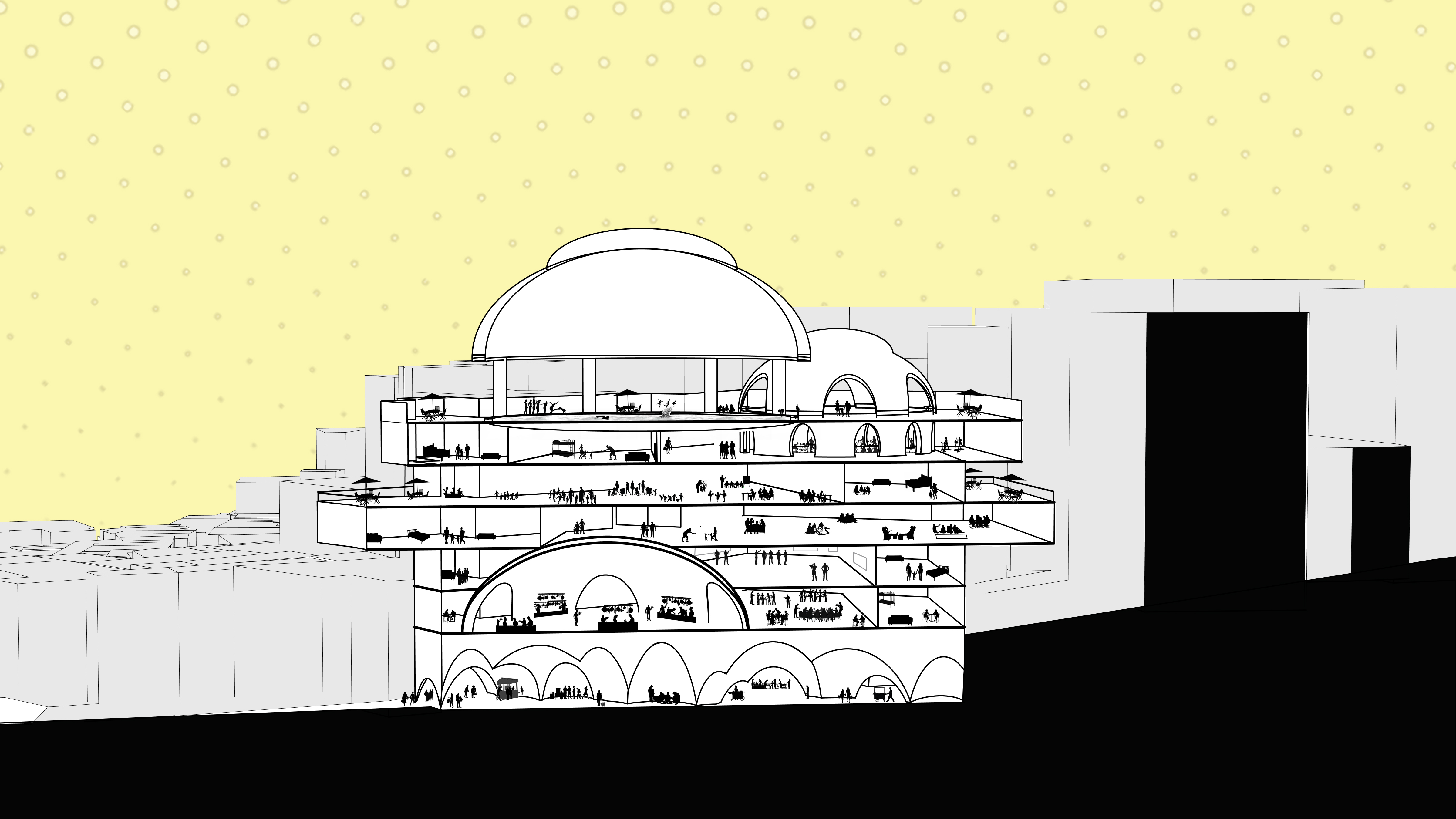
The Residential Bazaar
Istanbul, Turkey
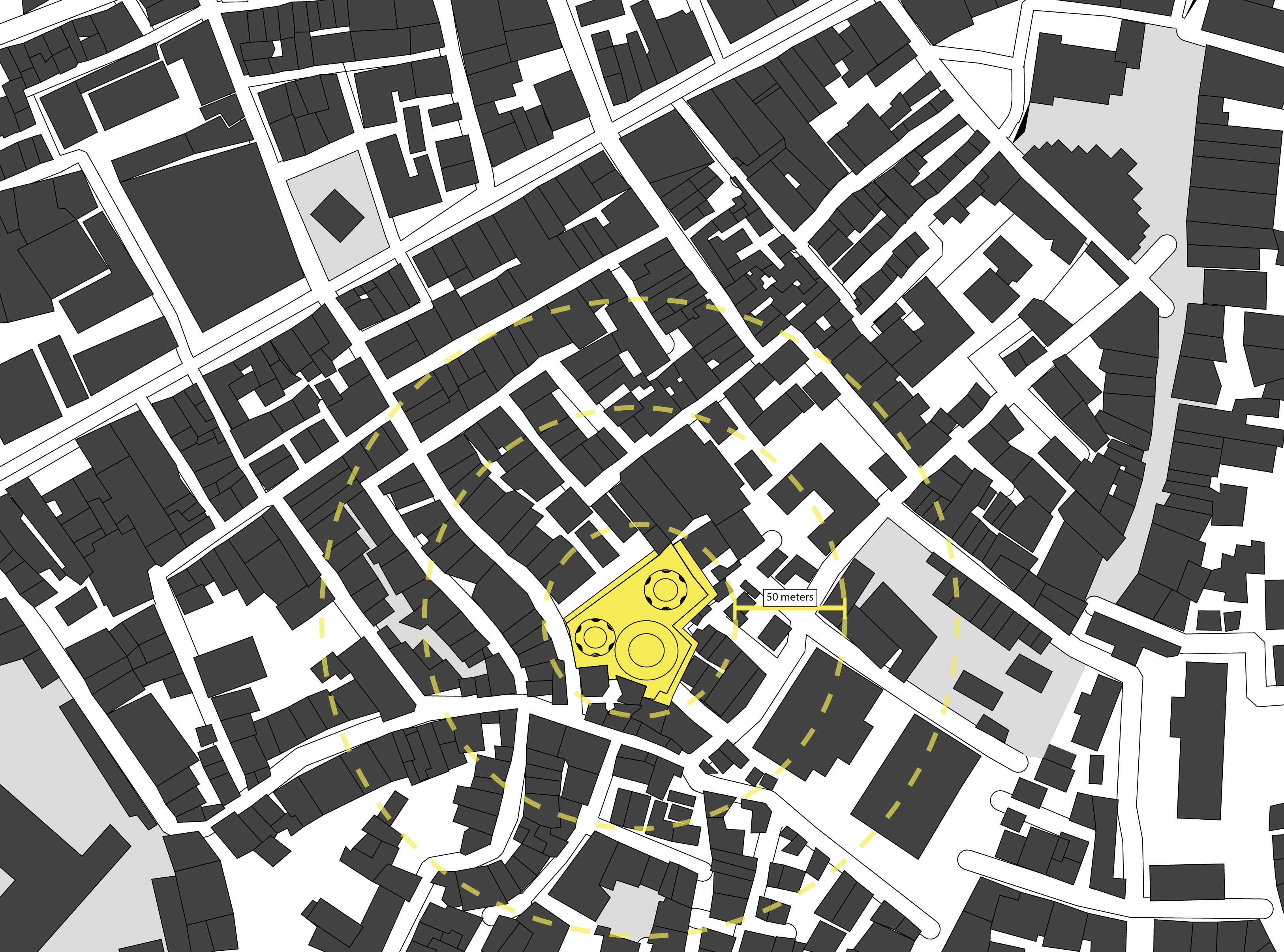
Sms Açık Otopark
Evliya Çelebi, 34433 Beyoğlu District, Tarlabaşı
The neighborhood of Tarlabaşı is located North of the Golden Horn, which lies to the south of Taksim Gezi Park. It is known as a Greek and Armenian neighborhood; however, many diverse ethnic groups live here today including Kurds, Turks, and Romani. It also houses different social groups who are often marginalized in the city consisting of transsexuals, sexworkers, or ‘illegal immigrants on their way to Europe.’ The neighborhood has problems regarding living space as well as equitable access to outdoor space. Many of the buildings are built very close together leaving little to no room for outdoor activities. The Bosporus Strait and Golden Horn are both nearby. However, each is used frequently by ferries, other traffic for tourists, and various commercial activities. The residential spaces are often overused and provide small living spaces with minimal facilities. There is also gentrification occurring north of the neighborhood which leaves the community with insufficient support and programmed opportunities. Old buildings are often demolished for profit and displace existing residents.
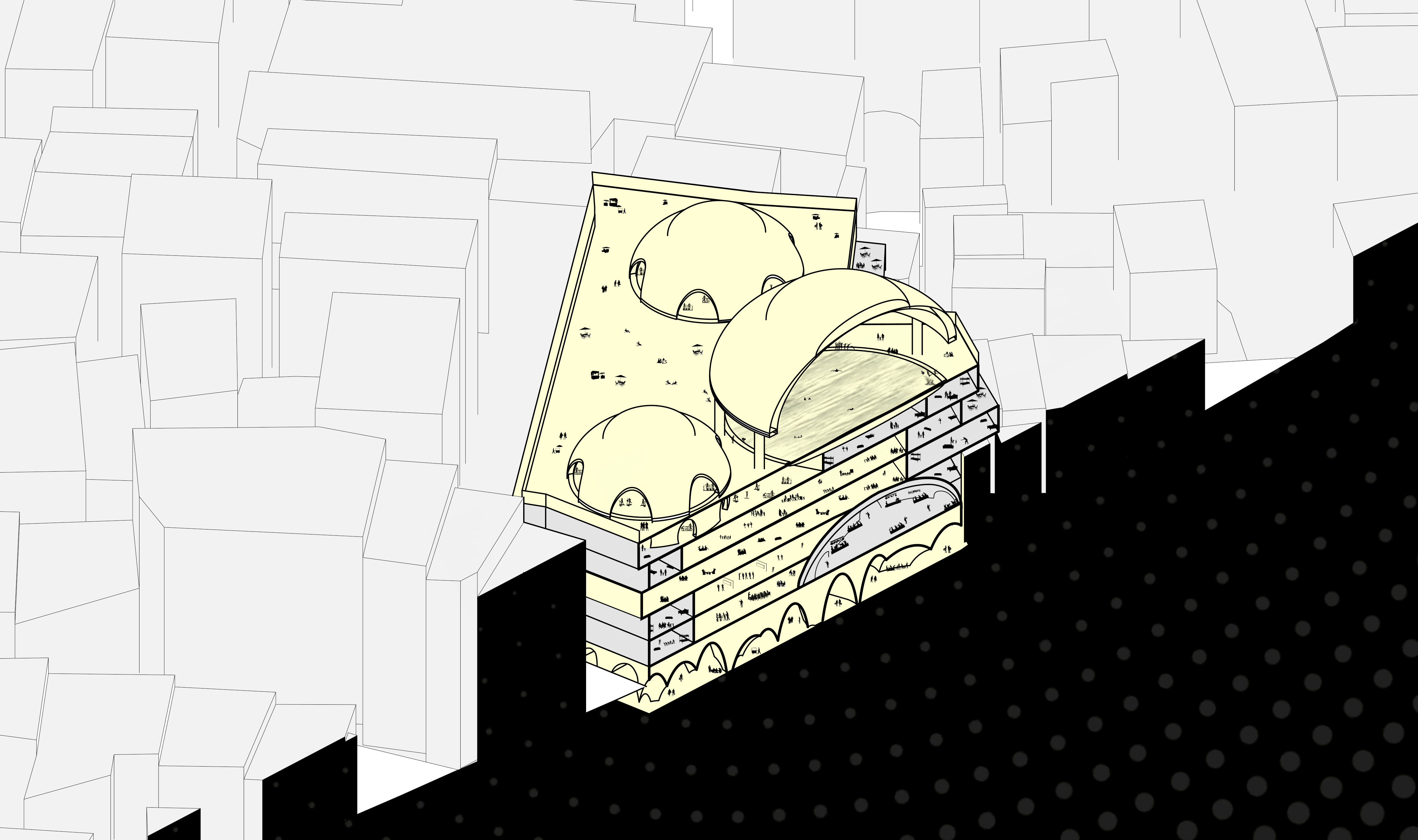
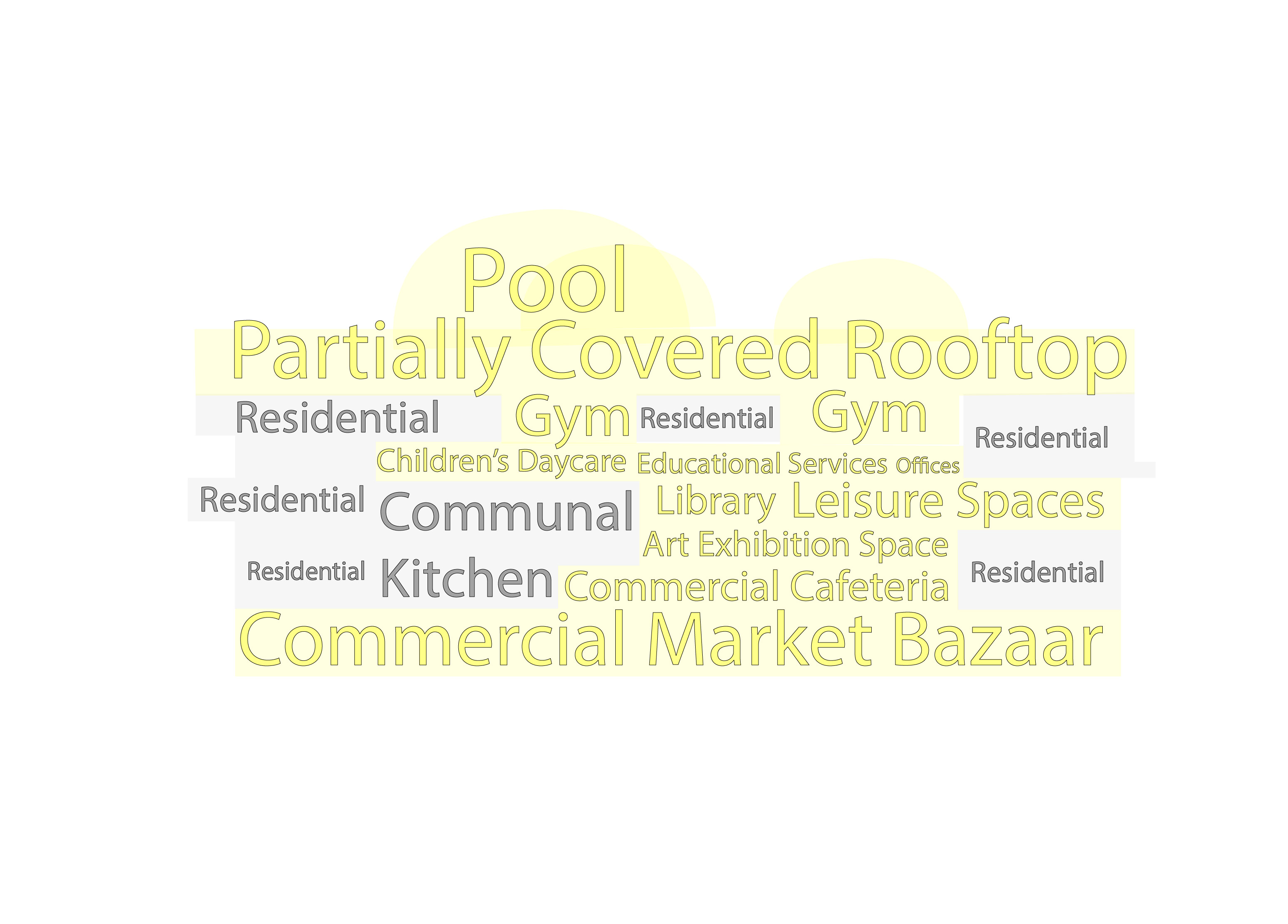
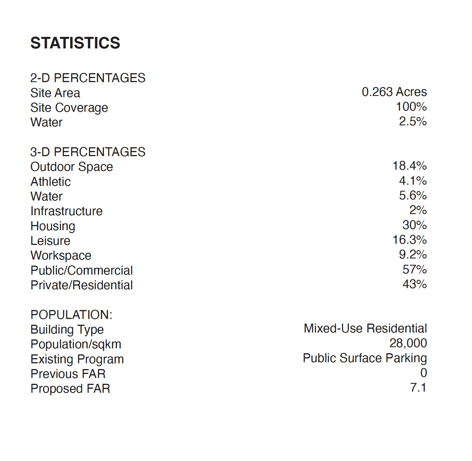
For the site location, a parking lot was intentionally selected as to not displace current occupants of any area. This parking lot is also nearby three other lots and two parking garages where residents and visitors can park alongside the site or within a hundred meter walking distance. A main goal of the project is to place emphasis on not disrupting the neighborhood; but instead provide support to the local community with additional affordable housing consisting of programmed opportunities. The Residential Bazaar attempts to provide equitable housing with commercial, educational, and communal opportunities supporting each other in one building.
Site Plan
Program

Section
Axonometric
Site Statistics
![]()
Sources:
First Assignment :
https://www.britannica.com/place/Istanbul
https://www.flickr.com/search/?q=istanbul
https://www.skyscrapercenter.com/city/istanbul
Residential Architecture & Urban Landscape In Istanbul Since 1950 by Sibel BozdoĞan
Istanbul City Population Index
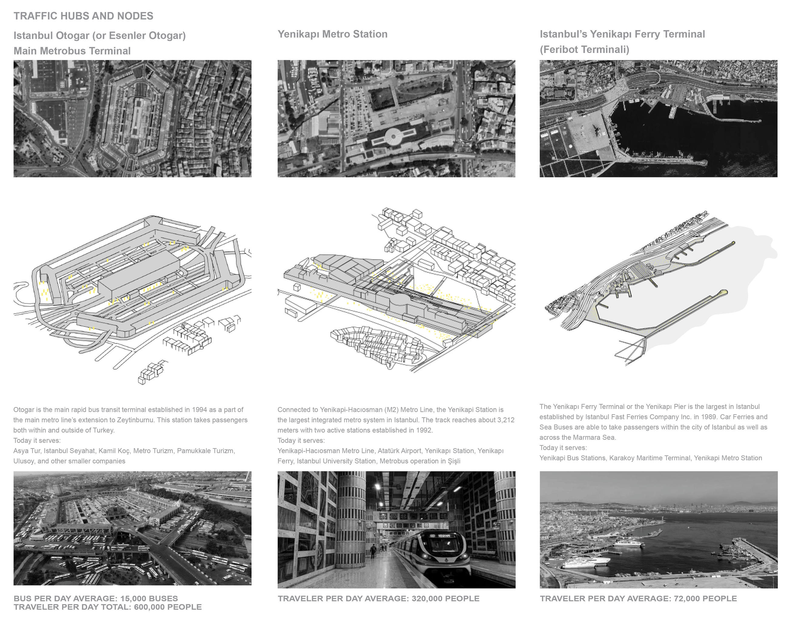
Other Means of Transportation in Istanbul
Public Transportation in Istanbul
“Lines in Operation” [Rail Systems]. Metro İstanbul. 2022. Retrieved 9 January 2022.
https://tuhim.ibb.gov.tr/media/2131/imm_transport_report.pdf
https://www.theguardian.com/cities/2015/may/28/istanbul-ferries-future-transport-new-york
Guide to Public Transportation in Istanbul
https://en.rayhaber.com/2019/11/yenikapi-haciosman-metro-saatleri-duraklari-ve-guzergahi/
https://www.travelturkeyinfo.com/yenikapi-ferry-port/
https://www.tooistanbul.com/en/public-transportation-istanbul/
Filling Istanbul’s Park Void with Mosques’ Green Spaces
A year after the protests, Gezi Park nurtures the seeds of a new Turkey
Historic Cemetery in Istanbul
https://www.britannica.com/place/Istanbul
https://www.roadiscalling.com/best-areas-in-istanbul-guide/
https://www.turkeyhomes.com/blog/post/districts-of-istanbul-39-areas-to-explore
https://www.istka.org.tr/media/66740/istanbul_fact_sheet_2017_en_english-web.pdf
https://populationstat.com/turkey/istanbul
https://www.macrotrends.net/cities/22691/istanbul/population
https://www.easyexpat.com/en/guides/turkey/istanbul/overview/politics.htm#google_vignette
https://www.ibb.istanbul/en
Map Image for CAD Tracing:
https://istanbeautiful.com/map-of-istanbul/
City Images:
https://www.flickr.com/search/?q=istanbul
https://commons.wikimedia.org/wiki/File:Skyscrapers_in_Izmir_-_Turkey.jpg
https://www.skyscrapercenter.com/city/istanb
Second Assignment:
Eminönü Neighborhood
https://data.ibb.gov.tr/en/dataset
http://www.istanbulurbandatabase.com/
https://www.frommers.com/destinations/istanbul/neighborhoods-in-brief
Acıbadem Neighborhood https://data.ibb.gov.tr/en/dataset
http://www.istanbulurbandatabase.com/
https://www.frommers.com/destinations/istanbul/neighborhoods-in-brief
https://www.kadikoy.bel.tr
https://www.ottsworld.com/blogs/istanbul-neighborhoods/
https://mapcarta.com/27602474
Tarlabaşi Neighborhood https://data.ibb.gov.tr/en/dataset
http://www.istanbulurbandatabase.com/
https://www.frommers.com/destinations/istanbul/neighborhoods-in-brief
http://www.beyoglu.gov.tr
http://www.tarlabasiistanbul.com/home.php
https://www.ottsworld.com/blogs/istanbul-view/
https://www.ottsworld.com/blogs/istanbul-markets-tarlabasi/
Sources:
First Assignment :
https://www.britannica.com/place/Istanbul
https://www.flickr.com/search/?q=istanbul
https://www.skyscrapercenter.com/city/istanbul
Residential Architecture & Urban Landscape In Istanbul Since 1950 by Sibel BozdoĞan
Istanbul City Population Index
Other Means of Transportation in Istanbul
Public Transportation in Istanbul
“Lines in Operation” [Rail Systems]. Metro İstanbul. 2022. Retrieved 9 January 2022.
https://tuhim.ibb.gov.tr/media/2131/imm_transport_report.pdf
https://www.theguardian.com/cities/2015/may/28/istanbul-ferries-future-transport-new-york
Guide to Public Transportation in Istanbul
https://en.rayhaber.com/2019/11/yenikapi-haciosman-metro-saatleri-duraklari-ve-guzergahi/
https://www.travelturkeyinfo.com/yenikapi-ferry-port/
https://www.tooistanbul.com/en/public-transportation-istanbul/
Filling Istanbul’s Park Void with Mosques’ Green Spaces
A year after the protests, Gezi Park nurtures the seeds of a new Turkey
Historic Cemetery in Istanbul
https://www.britannica.com/place/Istanbul
https://www.roadiscalling.com/best-areas-in-istanbul-guide/
https://www.turkeyhomes.com/blog/post/districts-of-istanbul-39-areas-to-explore
https://www.istka.org.tr/media/66740/istanbul_fact_sheet_2017_en_english-web.pdf
https://populationstat.com/turkey/istanbul
https://www.macrotrends.net/cities/22691/istanbul/population
https://www.easyexpat.com/en/guides/turkey/istanbul/overview/politics.htm#google_vignette
https://www.ibb.istanbul/en
Map Image for CAD Tracing:
https://istanbeautiful.com/map-of-istanbul/
City Images:
https://www.flickr.com/search/?q=istanbul
https://commons.wikimedia.org/wiki/File:Skyscrapers_in_Izmir_-_Turkey.jpg
https://www.skyscrapercenter.com/city/istanb
Second Assignment:
Eminönü Neighborhood
https://data.ibb.gov.tr/en/dataset
http://www.istanbulurbandatabase.com/
https://www.frommers.com/destinations/istanbul/neighborhoods-in-brief
Acıbadem Neighborhood https://data.ibb.gov.tr/en/dataset
http://www.istanbulurbandatabase.com/
https://www.frommers.com/destinations/istanbul/neighborhoods-in-brief
https://www.kadikoy.bel.tr
https://www.ottsworld.com/blogs/istanbul-neighborhoods/
https://mapcarta.com/27602474
Tarlabaşi Neighborhood https://data.ibb.gov.tr/en/dataset
http://www.istanbulurbandatabase.com/
https://www.frommers.com/destinations/istanbul/neighborhoods-in-brief
http://www.beyoglu.gov.tr
http://www.tarlabasiistanbul.com/home.php
https://www.ottsworld.com/blogs/istanbul-view/
https://www.ottsworld.com/blogs/istanbul-markets-tarlabasi/